Map notes
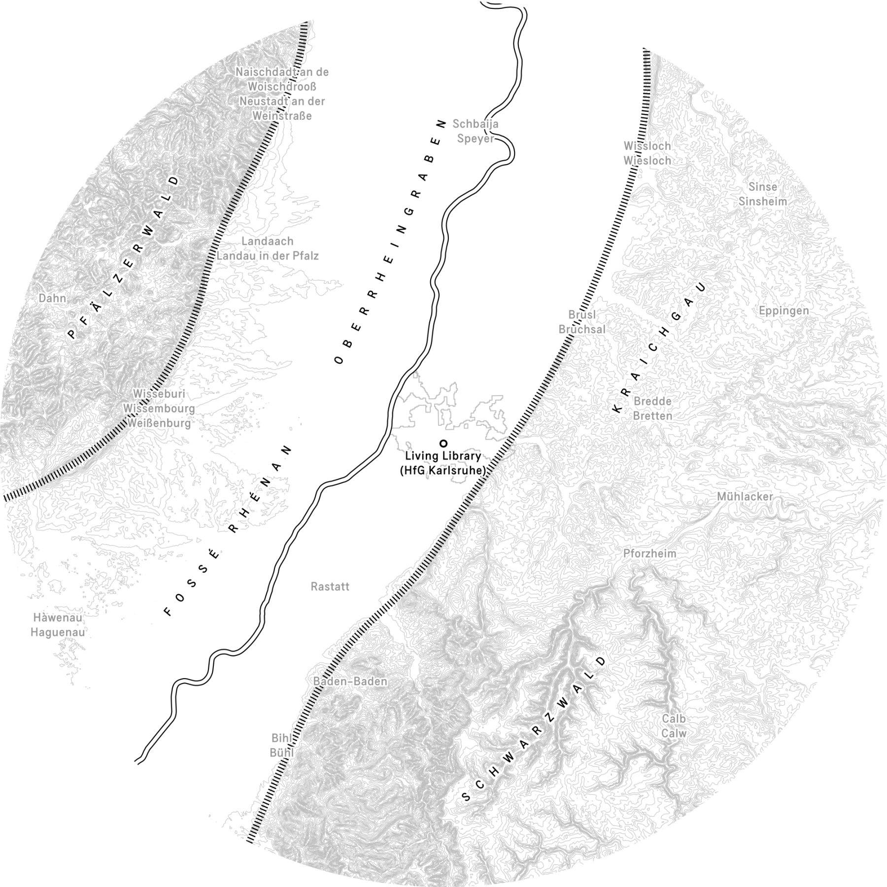
This base map shows the 50-kilometre radius that defines the Karlsruhe bioregion, with the Living Library at its centre. The region can be broadly divided into three areas: the Oberrheingraben/Upper Rhine Graben (framed by two fault lines indicated by dashed lines), a large rift valley formed about 50 million years ago with the river Rhine flowing northwards through its centre (double line); the Pfälzerwald/Palatinate Forest to the west; and the Schwarzwald/Black Forest to the east. The line pattern indicates elevation, revealing an almost flat Graben between two large mountain ranges. To reflect the region’s linguistic diversity, all cities on the map are written in both their local and national names.
Referenzen
- Bio Design Lab. 2020. ‘Bio Design Lab HfG Manual’. Staatliche Hochschule für Gestaltung Karlsruhe.
- Ertel, Lisa, and Anne-Sophie Oberkrome. 2020. ‘Atelier LUMA Meets ZKM’. With Atelier LUMA and Zentrum für Kunst und Medien. January 10.
- European Environment Agency. 2013. ‘Urban Morphological Zones 2006’. EEA geospatial data catalogue, June 28. https://www.eea.europa.eu/en/datahub/datahubitem-view/24129a43-4bc6-403a-aab8-7f500e69f8be.
- European Environment Agency, European Commission, and Copernicus Land Monitoring Service. 2019. ‘CORINE Land Cover 2018’. Version 20.01. European Environment Agency. FGeo,Spatialite. https://doi.org/10.2909/71C95A07-E296-44FC-B22B-415F42ACFDF0.
- European Space Agency (ESA) and Airbus. 2022. ‘Copernicus DEM’. Copernicus DEM. European Space Agency (ESA). https://doi.org/10.5270/esa-c5d3d65.
- Joint Research Centre (JRC) and European Commission. 2019. ‘LUCAS 2018 TOPSOIL’. European Soil Data Centre (ESDAC). https://esdac.jrc.ec.europa.eu/content/lucas-2018-topsoil-data.
- OpenDEM. 2018. ‘OpenDTM-DE’. April 8. www.opendem.info.
- OpenStreetMap contributors. 2024. ‘OpenStreetMap’. April 10. https://www.openstreetmap.org.
- Röhr, Christian. 2023. ‘Der Oberrheingraben’. January 25. https://www.oberrheingraben.de.
- Staatliches Museum für Naturkunde Karlsruhe. 2018. Geologie Am Oberrhein. Staatliches Museum für Naturkunde Karlsruhe, December.
- Stadtarchiv Karlsruhe and Stadt Karlsruhe. 2025. ‘Historische Pläne Der Stadt Karlsruhe’. July 29. https://stadtgeschichte.karlsruhe.de/materialien-zur-stadtgeschichte/historische-plaene-von-karlsruhe.