Map notes
This map coincides with our 5th workshop and colloquium: ‘Growth to Joinery: Rethinking wood as living material’ with Simon Gehring and Stefan Kudermann.
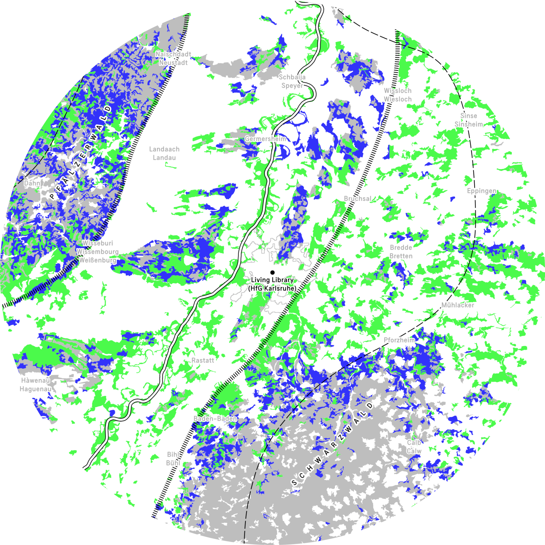
The region around Karlsruhe contains two large forests and several smaller ones, each with their own unique characteristics. In general, I decided to divide them into three types, each with their own colour: yellow areas where deciduous trees or broadleaf trees are dominant (Laubwald), grey areas where coniferous trees or pine trees are dominant (Nadelwald), and blue areas which contain a mix of both (Mischwald).
Looking at the map, the Black Forest (Schwarzwald) in the southeast and the Palatinate Forest (Pfälzerwald) in the northwest stand out. What we see of them in our local area are only small parts of their overal size, reaching out for over 100 kilometers beyond. What’s interesting is their composition. Our part of the Black Forest consists of predominantly pine trees with some mixed areas in the north. Our part of the Palatine Forest however is much more diverse with large parts of mixed forest and areas where both broadleaf and pine trees are dominant.
I asked our guest Stefan Kudermann, managing Director of Zentrum Holzbau Schwarzwald, about this difference. He explained that while the Black Forest is currently a monocultural forest with mostly pine trees, it was much more diverse until the 19th century. During that time, the commercial timber trade along the Rhine river for for instance shipbuilding in the Netherlands led to the Black Forest being almost completely deforested and later re-planted, resulting in the forest we see today. The Palatine Forest, although also used for harvesting timber, didn’t suffer as much due to early conservation efforts. The Palatine Forest, although also used for harvesting timber, didn’t suffer as much due to its location further inland and the early adoption of conservation efforts such as Hans Carl von Carlowitz’s ‘Nachhaltigkeit’ sustainable yield.
Jaap Knevel
References
- Brus, D.J. et al. (2012) ‘Statistical mapping of tree species over Europe’, European Journal of Forest Research, 131(1), pp. 145–157. Available at: https://doi.org/10.1007/s10342-011-0513-5.
- European Forest Institute and Alterra / Wageningen University and Research Centre (no date) ‘Forest Map of Europe’. Available at: https://efi.int/knowledge/maps/treespecies (Accessed: 7 July 2025).
- Stadt Karlsruhe and Liegenschaftsamt (2025) ‘Kalrsruhe Baumkataster’. Transparenzportal der Stadt Karlsruhe. Available at: https://transparenz.karlsruhe.de/dataset/fachplane-baumkataster1.