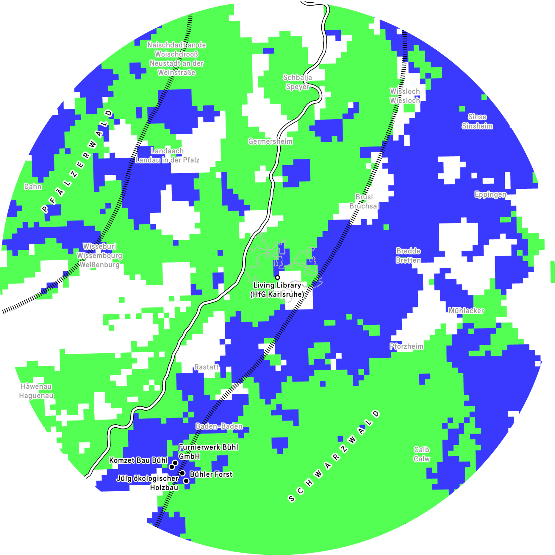
Karternotizen
Das pixelige Muster unterscheidet zwei Arten von Wald: Gebiete, in denen Laubbäume die dominierende Baumart sind (dunkle Schattierung), und Gebiete, in denen Nadelbäume vorherrschen (helle Schattierung). Diese Unterteilung ist zwar nicht absolut, liefert aber nützliche Informationen über das in den einzelnen Gebieten verfügbare Holz: Laubbaumarten produzieren in der Regel Hartholz, während Nadelbaumarten Weichholz liefern. Die im Rahmen des Lehrprogramms »Über Extraktion und Resilienz« rund um die Stadt Bühl besuchten Orte sind auf der Karte als ausgefüllte Punkte dargestellt.
Karlsruhe ist von einer vielfältigen Baum- und Waldlandschaft umgeben. Im Stadtgebiet sorgen rund 137.000 Straßen- und Parkbäume, vor allem Ahorn, Hainbuche, Eiche, Linde und Kirsche, für ein gutes Stadtklima. 9 Durch den Klimawandel wird bei neuen Pflanzungen zunehmend auf klimaresistente „Zukunftsbaumarten“ gesetzt. Der Hardtwald im Nordwesten ist geprägt von schnellwachsenden Kiefern, die nach dem Dreißigjährigen Krieg auf sandigen Böden aufgeforstet wurden. Im Süden bietet der Oberwald einen Laubmischbestand aus Stieleichen und Hainbuchen.
Südöstlich schließt sich der Schwarzwald an. Seine heutigen Fichten- und Tannenbestände sind historisch gewachsene Monokulturen, die nun schrittweise zu Mischwäldern umgeforstet werden.
Im Westen liegt der Pfälzerwald, Deutschlands größtes zusammenhängendes Waldgebiet. Dort sind unteranderem Rotbuchen, Kiefern, Eichen, Douglasien und Tannen heimig. Das Karlsruher Umland zeigt so ein breites Spektrum von Nadel- und Laubwäldern, das historisch, wirtschaftlich und ökologisch geprägt ist und sich zunehmend in Richtung artenreicher, klimaangepasster Bestände entwickelt.
Referenzen
- Brus, D. J., G. M. Hengeveld, D. J. J. Walvoort, et al. 2012. ‘Statistical Mapping of Tree Species over Europe’. European Journal of Forest Research 131 (1): 145–57. https://doi.org/10.1007/s10342-011-0513-5.
- European Forest Institute and Alterra / Wageningen University and Research Centre. n.d. ‘Forest Map of Europe’. Accessed 7 July 2025. https://efi.int/knowledge/maps/treespecies.
- Stadt Karlsruhe and Liegenschaftsamt. 2025. ‘Kalrsruhe Baumkataster’. Transparenzportal der Stadt Karlsruhe, January 3. https://transparenz.karlsruhe.de/dataset/fachplane-baumkataster1.